Major Bridges Bronx STATS 2021
BRONX WHITESTONE BRIDGE
Opened: April 29, 1939
Bridge Type: Suspension
Bridge
Purpose: Connects Ferry Point
in the Bronx with Whitestone in
Queens. Carries US Interstate
678 over the East River.
Maintenance: Triborough
Bridge and Tunnel Authority.
Size: The total length is 3,770
feet. Its longest span is 2,300
feet.
Daily Traffic: 112,971 (last
measured in 2010).
Information: Before the Bronx
Whitestone Bridge opened, the
Triborough Bridge (now the
Robert F. Kennedy Bridge), five
miles to the west, provided the
only vehicular connection between
Queens and the Bronx.
To help ease the congestion,
help motorists from upstate
New York and New England
reach Queens and Long Island
without traveling through the
traffic-ridden communities of
western Queens, and as part
of Robert Moses’ Belt Parkway
system around Brooklyn
and Queens, a new bridge was
born. The Bronx Whitestone
opened to traffic a mere 23
months after the awarding of
its first construction contract
so that motorists could cross
it on April 30, the opening day
of the 1939 New York World’s
Fair in Flushing Meadow Park.
The bridge spans the East
River and featured pedestrian
walkways as well as four lanes
of vehicular traffic. Those pedestrian
walkways were eventually
removed to enable the
addition of two more lanes of
vehicular traffic. On the Bronx
side are the residential communities
of Unionport and Schuylerville
and connections to the
Hutchinson River Parkway, the
Bruckner Expressway, and
the Cross Bronx Expressway.
As part of the massive bridge
project two major recreational
areas were developed, one of
which being Ferry Point Park in
the Bronx.
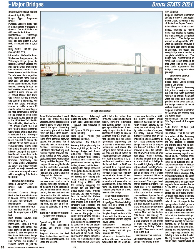
THROGS NECK BRIDGE
Opened: January 11, 1961
Bridge Type: Suspension
Bridge
Purpose: Connects Throgs
Neck in the Bronx with Bayside
in Queens. Carries six lanes of
I-295 over the East River.
Maintenance: Triborough
Bridge and Tunnel Authority.
Size: The total length is 2,910
feet. Its longest span is 1,800
feet
Daily Traffic: 108,455 (last
measured in 2010).
Information: Opened in 1961,
the Throgs Neck Bridge was
built between the Bronx and
Queens to ease congestion on
the Bronx Whitestone Bridge.
Traffi c on each of these bridges
now exceeds the number of
vehicles carried by just the
Bronx Whitestone when it stood
alone. The bridge was built
with long, curved approaches in
order to allow for water traffi c
beneath the span. Straddling
the meeting place of the East
River and Long Island Sound,
the bridge serves as a vital link
in the city’s interstate highway
system. On the Bronx side it
feeds into the Cross Bronx and
Bruckner expressways, the
Hutchinson River Parkway, and
the New England Thruway, providing
access to New Jersey,
upstate New York, Westchester
County. and New England. The
bridge’s Bronx neighborhoods
are the residential communities
of Throgs Neck and Locust
Point and the S.U.N.Y. Maritime
College at Fort Schuyler.
Since 2009, the bridge
has been under construction to
upgrade the bridge with changes
including a third supporting
pier, the removal of the median
barrier, the removal and replacement
of the old roadway
with a new superstructure, and
demolition of the old supporting
piers. The cost of the upgrade
is estimated at $192.8
million.
ROBERT F. KENNEDY BRIDGE
(formerly the Triborough
Bridge)
Opened: July 11, 1936
Bridge Type: Suspension
Bridge, Lift Bridge, Truss
Bridge
Purpose: Crosses the East
River, Harlem River and Bronx
Kill to connect Manhattan, the
Bronx and Queens.
Maintenance: Triborough
Bridge and Tunnel Authority.
Daily Traffic: Suspension Span
– 165,670 (last measured in
2006)
Lift Span – 87,606 (last measured
58 BRONX STATS - NOVEMBER 26, 2021 BTR
in 2010)
Truss Span – 79,996 (last
measured in 2010).
Information: The Robert F.
Kennedy Bridge (formerly the
Triborough Bridge) is the Triborough
Bridge and Tunnel
Authority’s flagship facility
and is actually three bridges,
a viaduct, and 14 miles of approach
roads connecting Manhattan,
Queens, and the Bronx.
Although the bridge opened in
1936, plans had actually been
in place since 1916, but did
not receive any funding until
1925. Construction began on
Black Friday in 1929. With
the economy struggling, the
outlook for the Triborough
Bridge looked bleak. Othmar
Ammann, the man who would
later be behind the Whitestone
and Throgs Neck bridges,
was brought in to simplify the
structure and collapsed the
original two-deck roadway into
one. New Deal money helped
to resurrect the project in the
early 1930’s with the eventual
opening on July 11, 1936. The
Bronx Crossing leads motorists
to points north via the Bruckner
and Deegan expressways
and, more locally, to the neighborhoods
of the South Bronx
and the Port Morris Industrial
Area. The Manhattan branch
is the Harlem River Lift Bridge,
which links the Harlem River
Drive, the FDR Drive, and 125th
Street, Harlem’s commercial
and cultural center. The longest
span of the Robert F. Kennedy
Bridge, the East River
Suspension Bridge to Queens,
connects with the Grand Central
Parkway and the Brooklyn
Queens Expressway and
to Astoria’s residential areas,
restaurants, and shops. The
bridge’s three branches meet
on Randall’s Island, where an
interchange and two toll plazas
sort out traffic flowing in 12 directions
and provide access to
the island itself. In 2008 and
pursuant to a request made
by the Kennedy family the Triborough
Bridge was officially
renamed after Robert F. Kennedy,
who served New York as
a senator, 40 years after his
assassination. Since then, the
term RFK-Triboro has become
increasingly popular as a nickname
for the bridge.
HENRY HUDSON BRIDGE
Opened: December 12, 1936
Bridge Type: Steel Arch Bridge
Size: The total length of the
bridge is 2,208 feet.
Purpose: Connects the
Spuyten Duyvil section of the
Bronx with the Northern end
of Manhattan over the Spuyten
Duyvil Creek.
Maintenance: Triborough
Bridge and Tunnel Authority.
Daily Traffic: 63,392 (last
measured in 2010).
Information: Named in honor
of Henry Hudson, the explorer
whose ship, the Half Moon, anchored
near this site in 1609,
the Henry Hudson Bridge
opened in 1936 as part of the
Henry Hudson Parkway by the
Henry Hudson Parkway Authority.
After a series of mergers,
the Henry Hudson Parkway
Authority became part of the
Triborough Bridge Authority in
1941. Today the Henry Hudson
Bridge remains one of Bridges
and Tunnels’ facilities, but the
parkway is under the jurisdiction
of New York City and New
York State. When it opened,
it was the longest plate girder
arch and fixed arch bridge in
the world. Originally built with
only one level, the bridge’s design
allowed for the construction
of a second level if traffic
demands increased. Within a
year and a half the upper level
was opened. The upper level
carries northbound traffic; the
lower one is for southbound
traffic. The bridge’s neighbors
to the north are the residential
communities of Spuyten Duyvil
and Riverdale, where single
family homes, wooded estates,
and large apartment complexes
share breathtaking views from
the sloping shoreline of the
Hudson River and the Harlem
Ship Canal. On January 20,
2011, the MTA implemented
a pilot program on the bridge
to phase out toll booths and
use open road tolling. Drivers
without E-ZPass would be sent
a bill in the mail.
SPUYTEN DUYVIL BRIDGE
Opened: December 12, 1900
Bridge Type: Swing Bridge
Size: 610 feet.
Purpose: Connects Manhattan
and the Bronx over the Spuyten
Duyvil Creek. It carries 1 line
of the Amtrak Empire Corridor.
Information: In 1899, a steel
bridge, designed by Robert
Giles, was created to replace
the original wooden bridge that
once stood. The bridge remained
standing until in 1983,
when an accident involving a
Circle Line boat left the bridge
in disrepair. The trestle and
swing bridge was in need of a
complete rehabilitation. The
bridge was reconstructed in
1991, and is now manned so
that when one of the Circle
Line boats approaches, the
bridge is swung open to allow
passage.
BROADWAY BRIDGE
Opened: July 1, 1962
Bridge Type: Double-decked
Vertical Lift Bridge
Size: The present Broadway
Bridge has a navigable channel
304 feet wide providing
136 feet of vertical clearance
when the bridge is in the open
position. In the down position,
the bridge provides 24 feet of
vertical clearance.
Purpose: Connects Manhattan
to the Bronx and crosses over
the Harlem River.
Maintenance: The New York
City Department of Transportation
Daily Traffic: 33,266 (last
measured in 2008)
Information: This is the third
incarnation of the Broadway
Bridge. During the late 1950’s,
the city decided to replace
the existing span with a new,
stronger Broadway Bridge.
The 2,500-ton span more than
doubled roadway capacity and
added another subway track
across the Harlem River. The
lower deck supports two 34-
foot wide roadways for vehicular
traffi c (For 2005, the NYC
Department of Transportation
reported annual average daily
traffi c volume in both directions
of 35,698) and two 8-foot wide
sidewalks, while the upper deck
supports three elevated tracks
for the IRT #1 and #9 subway
lines. For water traffi c, the
bridge has a navigable channel
304 feet wide, more than triple
the width of the navigable channels
of the old bridge. In the
open position, the bridge has a
vertical clearance of 136 feet.
In 2003, the NYCDOT completed
a $10 million minor rehabilitation
of the Broadway Bridge.
This work included applying a
protective coating to the steel
components of the lift span,
installing new expansion joints,
sealing and waterproofi ng the
deck, repairing concrete, and
building a new median barrier.
The city plans a three-year, $22
million major reconstruction of
Throgs Neck Bridge