18 FEBRUARY 8, 2018 RIDGEWOOD TIMES WWW.QNS.COM
OUR NEIGHBORHOOD: THE WAY IT WAS
The twists and turns of some
historic Queens roadways
BY THE OLD TIMER
EDITORIAL@RIDGEWOODTIMES.COM
@RIDGEWOODTIMES
The early roads in Queens and
on Long Island were dirt paths
that led from one community to
another — or, because water transportation
was important, to the nearest
boat landing.
The roads had to be wide enough
to permit a wagon pulled by a team
of horses to be able to turn around
without backing up. The names of the
roads were simple, usually telling you
where they went.
Some of the early roads followed Native
American trails which were paths
that generally followed the easiest way
to get from one place to another. The
Native Americans along the south
shore were the Rockaways, and they
moved trade goods over the Rockaway
Trail, part of which later became Fresh
Pond Road.
Here’s some details about some of
Queens’ most famous streets which
are still part of our lives today:
Dry Harbor Road (originally spelled
Dry Harbour) was a wagon path created
about 1780 from what is now 62nd
Avenue and Woodhaven Boulevard,
to the cluster of farms at Dry Harbour,
the name from Cooper Avenue to
about Myrtle Avenue in proximity to
this road.
To open up the lands for settlement,
it was necessary to have roads so that
the farmers could travel to and from
their farms, and also to their wood
lots where they chopped down trees to
provide fi rewood to heat their homes
in the winter time. The wagon path of
1780 replaced an earlier trail.
Whereas the South Meadow Road
(present-day Woodhaven Boulevard)
ran through the Hempstead Swamp
and was a wet, boggy road, the Dry
Harbour Road skirted the western
edge of the swamp and was completely
dry to the south. Although the road
today (now 80th and 81st Streets) stops
at Myrtle Avenue, at one time, it proceeded
south to the Brooklyn-Jamaica
Turnpike (now Jamaica Avenue).
* * *
Cooper Avenue was named for
Richard Cooper, who had a 40-acre
farm that straddled the Kings/Queens
County border. His farmhouse was
on the south side of the road, about
a quarter-mile west of what is now
Cypress Avenue.
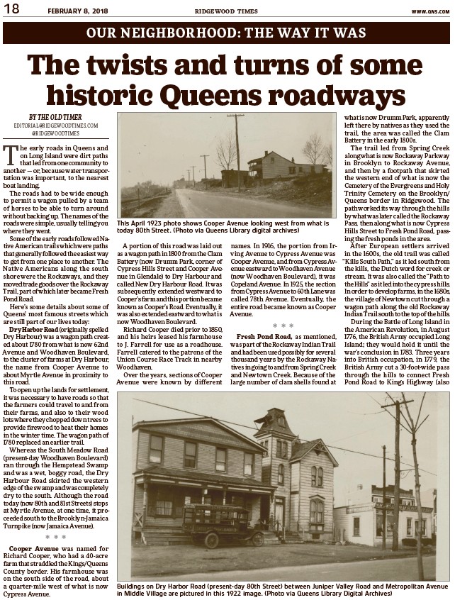
This April 1923 photo shows Cooper Avenue looking west from what is
today 80th Street. (Photo via Queens Library digital archives)
A portion of this road was laid out
as a wagon path in 1800 from the Clam
Battery (now Drumm Park, corner of
Cypress Hills Street and Cooper Avenue
in Glendale) to Dry Harbour and
called New Dry Harbour Road. It was
subsequently extended westward to
Cooper’s farm and this portion became
known as Cooper’s Road. Eventually, it
was also extended eastward to what is
now Woodhaven Boulevard.
Richard Cooper died prior to 1850,
and his heirs leased his farmhouse
to J. Farrell for use as a roadhouse.
Farrell catered to the patrons of the
Union Course Race Track in nearby
Woodhaven.
Over the years, sections of Cooper
Avenue were known by different
names. In 1916, the portion from Irving
Avenue to Cypress Avenue was
Cooper Avenue, and from Cypress Avenue
eastward to Woodhaven Avenue
(now Woodhaven Boulevard), it was
Copeland Avenue. In 1925, the section
from Cypress Avenue to 60th Lane was
called 78th Avenue. Eventually, the
entire road became known as Cooper
Avenue.
* * *
Fresh Pond Road, as mentioned,
was part of the Rockaway Indian Trail
and had been used possibly for several
thousand years by the Rockaway Natives
in going to and from Spring Creek
and Newtown Creek. Because of the
large number of clam shells found at
what is now Drumm Park, apparently
left there by natives as they used the
trail, the area was called the Clam
Battery in the early 1800s.
The trail led from Spring Creek
along what is now Rockaway Parkway
in Brooklyn to Rockaway Avenue,
and then by a footpath that skirted
the western end of what is now the
Cemetery of the Evergreens and Holy
Trinity Cemetery on the Brooklyn/
Queens border in Ridgewood. The
path worked its way through the hills
by what was later called the Rockaway
Pass, then along what is now Cypress
Hills Street to Fresh Pond Road, passing
the fresh ponds in the area.
After European settlers arrived
in the 1600s, the old trail was called
“Kills South Path,” as it led south from
the kills, the Dutch word for creek or
stream. It was also called the “Path to
the Hills” as it led into the cypress hills.
In order to develop farms, in the 1680s,
the village of Newtown cut through a
wagon path along the old Rockaway
Indian Trail south to the top of the hills.
During the Battle of Long Island in
the American Revolution, in August
1776, the British Army occupied Long
Island; they would hold it until the
war’s conclusion in 1783. Three years
into British occupation, in 1779, the
British Army cut a 30-foot-wide pass
through the hills to connect Fresh
Pond Road to Kings Highway (also
Buildings on Dry Harbor Road (present-day 80th Street) between Juniper Valley Road and Metropolitan Avenue
in Middle Village are pictured in this 1922 image. (Photo via Queens Library Digital Archives)