WARNINGS AHEAD
coast could fl ood annually by 2050: Study
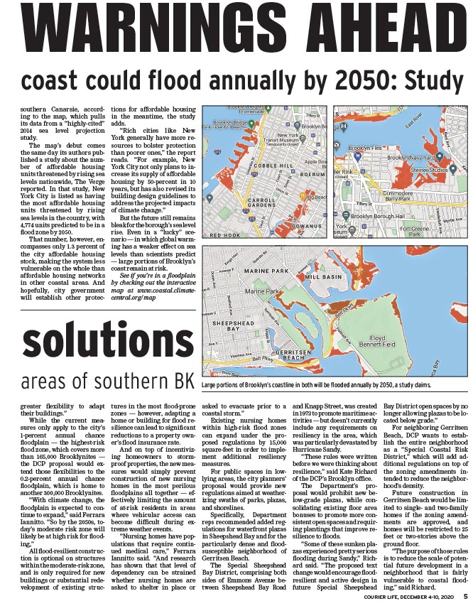
Large portions of Brooklyn’s coastline in both will be fl ooded annually by 2050, a study claims.
COURIER LIFE, DECEMBER 4-10, 2020 5
southern Canarsie, according
to the map, which pulls
its data from a “highly-cited”
2014 sea level projection
study.
The map’s debut comes
the same day its authors published
a study about the number
of affordable housing
units threatened by rising sea
levels nationwide, The Verge
reported. In that study, New
York City is listed as having
the most affordable housing
units threatened by rising
sea levels in the country, with
4,774 units predicted to be in a
fl ood zone by 2050.
That number, however, encompasses
only 1.3 percent of
the city affordable housing
stock, making the system less
vulnerable on the whole than
affordable housing networks
in other coastal areas. And
hopefully, city government
will establish other protections
for affordable housing
in the meantime, the study
adds.
“Rich cities like New
York generally have more resources
to bolster protection
than poorer ones,” the report
reads. “For example, New
York City not only plans to increase
its supply of affordable
housing by 50-percent in 10
years, but has also revised its
building design guidelines to
address the projected impacts
of climate change.”
But the future still remains
bleak for the borough’s sea level
rise. Even in a “lucky” scenario
— in which global warming
has a weaker effect on sea
levels than scientists predict
— large portions of Brooklyn’s
coast remain at risk.
See if you’re in a fl oodplain
by checking out the interactive
map at www.coastal.climatecentral.
org/map
solutions
areas of southern BK
greater fl exibility to adapt
their buildings.”
While the current measures
only apply to the city’s
1-percent annual chance
fl oodplain — the highest-risk
fl ood zone, which covers more
than 165,000 Brooklynites —
the DCP proposal would extend
those fl exibilities to the
0.2-percent annual chance
fl oodplain, which is home to
another 300,000 Brooklynites.
“With climate change, the
fl oodplain is expected to continue
to expand,” said Ferrara
Iannitto. “So by the 2050s, today’s
moderate risk zone will
likely be at high risk for fl ooding,”
All fl ood-resilient construction
is optional on structures
within the moderate-risk zone,
and is only required for new
buildings or substantial redevelopment
of existing structures
in the most fl ood-prone
zones — however, adapting a
home or building for fl ood resilience
can lead to signifi cant
reductions to a property owner’s
fl ood insurance rate.
And on top of incentivizing
homeowners to stormproof
properties, the new measures
would simply prevent
construction of new nursing
homes in the most perilous
fl oodplains all together — effectively
limiting the amount
of at-risk residents in areas
where vehicular access can
become diffi cult during extreme
weather events.
“Nursing homes have populations
that require continued
medical care,” Ferrara
Iannitto said. “And research
has shown that that level of
dependency can be strained
whether nursing homes are
asked to shelter in place or
asked to evacuate prior to a
coastal storm.”
Existing nursing homes
within high-risk fl ood zones
can expand under the proposed
regulations by 15,000
square-feet in order to implement
additional resiliency
measures.
For public spaces in lowlying
areas, the city planners’
proposal would provide new
regulations aimed at weatherizing
swaths of parks, plazas,
and shorelines.
Specifi cally, Department
reps recommended added regulations
for waterfront plazas
in Sheepshead Bay and for the
particularly dense and fl oodsusceptible
neighborhood of
Gerritsen Beach.
The Special Sheepshead
Bay District, comprising both
sides of Emmons Avenue between
Sheepshead Bay Road
and Knapp Street, was created
in 1973 to promote maritime activities
— but doesn’t currently
include any requirements on
resiliency in the area, which
was particularly devastated by
Hurricane Sandy.
“These rules were written
before we were thinking about
resilience,” said Kate Richard
of the DCP’s Brooklyn offi ce.
The Department’s proposal
would prohibit new below
grade plazas, while consolidating
existing fl oor area
bonuses to promote more consistent
open spaces and requiring
plantings that improve resilience
to fl oods.
“Some of these sunken plazas
experienced pretty serious
fl ooding during Sandy,” Richard
said. “The proposed text
change would encourage fl oodresilient
and active design in
future Special Sheepshead
Bay District open spaces by no
longer allowing plazas to be located
below grade.”
For neighboring Gerritsen
Beach, DCP wants to establish
the entire neighborhood
as a “Special Coastal Risk
District,” which will add additional
regulations on top of
the zoning amendments intended
to reduce the neighborhood’s
density.
Future construction in
Gerritsen Beach would be limited
to single- and two-family
homes if the zoning amendments
are approved, and
homes will be restricted to 25
feet or two-stories above the
ground fl oor.
“The purpose of those rules
is to reduce the scale of potential
future development in a
neighborhood that is fairly
vulnerable to coastal fl ooding,”
said Richard.
/map
/map
/map