2
BROOKLYN WEEKLY, JULY 26, 2020
Mapper’s delight
Pols call to waive fi nes from shifting outdoor dining guidelines
BY JESSICA PARKS
Two Bay Ridge lawmakers are
calling on city transportation offi -
cials to waive fi nes issued to restaurants
as a result of shifting outdoor
dining regulations at a time when
many city eateries are struggling
to stay afl oat following a statewide
shutdown of most businesses to
stem the spread of COVID-19.
“Safety comes fi rst, so we understand
that the city may need to
adjust its guidelines after administering
this program so rapidly. But
restaurants should not be fi ned
when the goalposts are still shifting,”
said City Councilman Justin
Brannan. “The Open Restaurants
program is supposed to help restaurants
get back in the green —
saddling them with fi nes is the exact
opposite of what we should be
doing.”
Brannan is joined by State Senator
Andrew Gounardes in his call
for leniency, which comes on the
heels of borough restaurants being
threatened with heavy fi nes
their outdoor dining spaces no longer
complied with the adjustments
made to the original guidelines.
“It is outrageous to cause local
restaurants, already struggling to
stay in business, to have to spend
thousands of extra dollars to comply
with changing guidelines,”
Gounardes said. “The city must
forgive any fi nes levied under this
program and commit to clear, consistent
guidelines going forward.”
In recent weeks, restaurants
found out of compliance have been
told they have 24 hours to bring their
outdoor dining areas to code, which
some restaurant owners told Brooklyn
Paper cost them additional hundreds
of dollars on top of the original
cost of building the space.
“We spent a couple of thousand
dollars on everything else,” said
Antonio Viscoso, owner of Vesuvio,
an Italian restaurant on Third Avenue
in Bay Ridge. “Then, I think
we spent another $1,200 on umbrellas
and weighted stands.”
Though Viscoso was not hit
with heavy fi nes, he was told the
outside tents he had purchased for
outdoor dining were out of compliance
and after purchasing umbrellas
to use instead, he was told the
outdoor tents would be permitted.
“We had a tent, we had to take
the tent down, then we bought the
umbrellas and after that, we were
told the tents were good,” Viscoso
said. “But we had already given
our tents away.”
Overall, the owner said, he
is pleased with the city’s outdoor
dining regulations and how
quickly offi cials were able to roll
them out as the switch to al-fresco
dining provides a much-needed
source of revenue for local businesses
following the months-long
shutdown.
“I am pretty satisfi ed with it,
there was bit of bouncing back and
forth, but once everything worked
out- it’s not a bad thing,” Viscoso
said. “They extended outdoor dining
until October 31st, like everyone
else it’s better than nothing.”
In the meantime, Brannan and
Gounardes urge any local business
owner who receives a fi ne
for their outdoor dining setup to
reach out to either of their offi ces.
“I understand this program
is brand new and was enacted
at a frenetic pace. I also understand
the need to get the guidelines
right,” Brannan said. “Fines
should be forgiven, and if guidelines
change yet again, then business
owners need to be given
more time to fi x – otherwise we
are hurting our small businesses
and this program was supposed to
help them get through this tough
time.”
Diners have lunch outdoors at the Salty Dog in Bay Ridge. Photo by Caroline Ourso
BY ROSE ADAMS
An online map portal launched on July
16 by the Brooklyn Historical Society provides
access to hundreds of rare Brooklyn
maps dating back to the 1700s, giving viewers
a look into the borough’s development
over the centuries, according to the project’s
creator.
“The most dramatic story that these
maps show is the evolution of Brooklyn from
this primarily agricultural place of villages
to then, over the course of the 19th century,
becoming increasingly urban,” said Maggie
Schreiner, the manager of archives and special
collections, and the project’s co-director.
“That story is very clear in these maps.”
The online database, which includes
nearly 1,500 maps from across the state, allows
viewers to sort through fragile, one-ofa
kind artifacts from the Society’s archives,
many of which have not been displayed publicly
for several decades, Schreiner said.
“Hundreds of the maps that are included
in the portal are manuscript maps, so
they’re hand-drawn maps,” she said. “Many
of these maps are very large format, they’re
very fragile, so they’re quite hard to pull for
researchers in our reading room.”
Some of the collection’s oldest maps include
rare British surveys of the territory
before the Revolutionary War, and maps
from before the city of Brooklyn was incorporated
into New York City in 1834, Society
reps said in a statement.
Brooklynites can sort through the portal’s
nearly 900 Brooklyn maps by location,
allowing them to view their neighborhood
as it looked more than 100 years ago, and
to see the changes to its transportation networks
and population.
Users can also search by topic or genre to
fi nd a range of transportation maps, political
maps, topographical maps, and cultural
maps, among other more specifi c topics.
Some of the portal’s most popular maps
show old public transportation routes,
Schreiner said.
“One of the maps that’s been really popular
the fi rst couple days is a map that shows
how to get to Ebbet’s Field from 1919 —
that stadium where the Brooklyn Dodgers
played,” she said.
Staffers at the Brooklyn Historical Society
worked on the portal project for more
than two years, restoring the maps, sending
them to New Jersey to be digitized, and
locating them on a present-day grid using
mapping software, Schreiner said.
“To digitize the maps, we did that in New
Jersey … that was a big undertaking,” she
said. “We also GIS-located every single map,
so if you look up every single map it shows a
location box that shows the present day location
of where that map is.”
The Brooklyn Historical Society —
which unveiled an online portal a few years
ago with more than 1,200 oral histories from
across the borough — has turned to digitization
to expand access to its collections so
that academics and inquisitive Brooklynites
can take a peek into the borough’s history.
“Our goal was to create a portal that will
be used by the full range of people,” said
Schreiner, who added that the Society prioritizes
digitizing collections that are diffi cult
to display in person. “It’s a tool for those doing
academic research, but also a place for
those curious about their streets and neighborhoods.
Anyone can visit and take a journey.”
You can visit the online map portal at
www.mapcollections.brooklynhistory.org.
New map database chronicles BK’s development
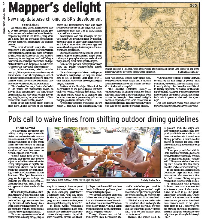
This 1864 copy of a 1766 map, “Plan of the village of Brooklyn and part of Long Island,” is one of the
oldest views of the city in the library’s map collection. Brooklyn Historical Society
/www.mapcollections.brooklynhistory.org
/www.mapcollections.brooklynhistory.org