OUR ESSENTIAL GUIDE TO THE BOROUGH OF KINGS
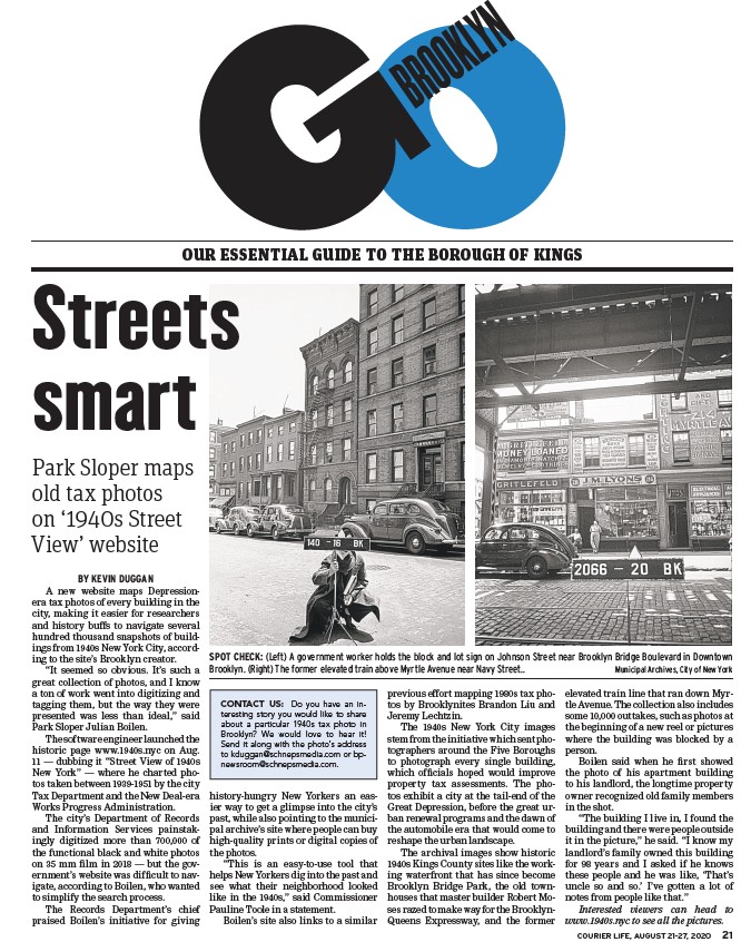
SPOT CHECK: (Left) A government worker holds the block and lot sign on Johnson Street near Brooklyn Bridge Boulevard in Downtown
Brooklyn. (Right) The former elevated train above Myrtle Avenue near Navy Street.. Municipal Archives, City of New York
COURIER LIFE, AUGUST 21-27, 2020 21
BY KEVIN DUGGAN
A new website maps Depressionera
tax photos of every building in the
city, making it easier for researchers
and history buffs to navigate several
hundred thousand snapshots of buildings
from 1940s New York City, according
to the site’s Brooklyn creator.
“It seemed so obvious. It’s such a
great collection of photos, and I know
a ton of work went into digitizing and
tagging them, but the way they were
presented was less than ideal,” said
Park Sloper Julian Boilen.
The software engineer launched the
historic page www.1940s.nyc on Aug.
11 — dubbing it “Street View of 1940s
New York” — where he charted photos
taken between 1939-1951 by the city
Tax Department and the New Deal-era
Works Progress Administration.
The city’s Department of Records
and Information Services painstakingly
digitized more than 700,000 of
the functional black and white photos
on 35 mm fi lm in 2018 — but the government’s
website was diffi cult to navigate,
according to Boilen, who wanted
to simplify the search process.
The Records Department’s chief
praised Boilen’s initiative for giving
history-hungry New Yorkers an easier
way to get a glimpse into the city’s
past, while also pointing to the municipal
archive’s site where people can buy
high-quality prints or digital copies of
the photos.
“This is an easy-to-use tool that
helps New Yorkers dig into the past and
see what their neighborhood looked
like in the 1940s,” said Commissioner
Pauline Toole in a statement.
Boilen’s site also links to a similar
previous effort mapping 1980s tax photos
by Brooklynites Brandon Liu and
Jeremy Lechtzin.
The 1940s New York City images
stem from the initiative which sent photographers
around the Five Boroughs
to photograph every single building,
which offi cials hoped would improve
property tax assessments. The photos
exhibit a city at the tail-end of the
Great Depression, before the great urban
renewal programs and the dawn of
the automobile era that would come to
reshape the urban landscape.
The archival images show historic
1940s Kings County sites like the working
waterfront that has since become
Brooklyn Bridge Park, the old townhouses
that master builder Robert Moses
razed to make way for the Brooklyn-
Queens Expressway, and the former
elevated train line that ran down Myrtle
Avenue. The collection also includes
some 10,000 outtakes, such as photos at
the beginning of a new reel or pictures
where the building was blocked by a
person.
Boilen said when he fi rst showed
the photo of his apartment building
to his landlord, the longtime property
owner recognized old family members
in the shot.
“The building I live in, I found the
building and there were people outside
it in the picture,” he said. “I know my
landlord’s family owned this building
for 98 years and I asked if he knows
these people and he was like, ‘That’s
uncle so and so.’ I’ve gotten a lot of
notes from people like that.”
Interested viewers can head to
www.1940s.nyc to see all the pictures.
Streets
smart
Park Sloper maps
old tax photos
on ‘1940s Street
View’ website
CONTACT US: Do you have an interesting
story you would like to share
about a particular 1940s tax photo in
Brooklyn? We would love to hear it!
Send it along with the photo’s address
to kduggan@schnepsmedia.com or bpnewsroom@
schnepsmedia.com.
link
/www.1940s.nyc
link
link
/www.1940s.nyc
/www.1940s.nyc
/www.1940s.nyc
/schnepsmedia.com
link