6 Brooklyn Paper • www.BrooklynPaper.com • (718) 260-2500 January 17–23, 2020
KOREAN K9
Photo by Ben Verde
& NORTH SHORE ANIMAL LEAGUE AMERICA
A D O PT
A PET!
Playground
to parking lot
Photo courtesy
of Ellen Dunn
NYC Pet
475 Driggs Ave. �� Brooklyn, NY
SATURDAY �� JANUARY 18
10:30 AM - 4:30 PM
25 Davis Ave., Port Washington, NY 11050
516.883.7575 • animalleague.org • RR006
Over 75 years FOLLOW US ON:
Greenwood slights!
MTA map eliminates nabe in favor of expanded Slope
BIKES...
����������������������������������
��������������������������������������������������������������������������
����������������������������������������������������������������
����������������������������������������������������
��������������������������������������������������������������������������������������������������������������������������������������������������
��
����������������������������������������
�������������������������������������� ��
������������������������������������ ��
������������������������������������������������
����������������������������������������������
��������������������������������������
������������������������������������������������
������������������������������
����������������������������������������������������
����������������������������������������������������������������������������
����������������������
��
��
��������������������������������������
����������������������������������������
������������������������������������
����������������������������������������������������������������������������������������������������������������������������������������������������������������������������������������������������������������������������������������������������������������������������������������
����������
������������������ ������������������������������������������������������������������������������������������������������������ �������������������������������������������������������� �������������������������������� �������� ������������������ ������
������������������������������������������������
����������������������������������������
�������������������������������������� ���������� ���� lane also located on the western
side of the road, which
the city plans to separate from
motor-vehicle traffic with
floppy plastic flappers.
The plans require 15 parking
spaces get the ax, most
of which are located along
Quay Street near a Metropolitan
Transportation Authority
storage depot.
The Authority will also
have to relocate the Williamsburg
bound B32 bus stop at
Franklin Street and Meserole
Avenue to accommodate
the bike lane, although
MTA officials haven’t figured
out where they want to
move it yet.
One small business owner
expressed concerns that the
new bike lanes would interfere
with pickups and deliveries
at his Franklin Street
clothing store, and claimed
that he lost customers when
the cycling paths were first
installed as a result of his
driveway being blocked, although
he noted the city later
corrected the problem.
“I literally lost about 60
percent of my business last
time” said Steve Rosenberg,
the owner of Pops Popular
Clothing. “As soon as the bike
lanes were made with access
to the driveways, my business
came right back up.”
A DOT rep said the agency
will not place the concrete
barriers and plastic flappers
in front of driveways adding
that officials will meet
with all businesses to discuss
the changes in the coming
months.
Several committee members
praised the city’s move,
with one cyclist saying that
area is in dire need of safety
improvements — adding that
she also regularly patronizes
Pops.
Continued from page 1
Department of Transportation
The city plans to consolidate the existing bike lanes
into a two-way path on the west side of the street
with a concrete buffer protecting it from oncoming
traffic.
“That stretch is horrific and
the sooner it can get done the
better, because that spot is not
safe at all,” said Ryan Kuonen.
“I bike to Pops all the time… I
also appreciate Pops up, down,
and around town, just to let
you know.”
By Ben Verde
Brooklyn Paper
The Metropolitan Transportation
Authority stuck its
foot in a contentious debate
that’s divide Brooklynites for
decades — where does Park
Slope end and Greenwood
Heights begin?
A recently installed map at
the 25th Street subway station
places the bougie brownstone
neighborhood well below the
Prospect Expressway, where
the moniker “Park Slope” is
labeled confidently, despite
the area’s namesake greenspace,
Prospect Park, ending
at 15th Street and Greenwood
Cemetery taking over as the
most prominent landmark.
The faux pas sparked a
lively debate on the Brooklyn
sub-Reddit page, where
user CallYaMuthaAlreddie
claimed that 15th Street remains
Park Slope’s definitive
southern boundary.
“This map is wrong,” wrote
the Reddit user. “Park Slope
ends at 15th street, where the
park ends. There’s no park to
slope from at Prospect Avenue.”
The MTA’s map also refutes
the Brooklyn Paper
newsroom’s handy map of the
borough, where Greenwood
Heights is located south of the
expressway, and which this
publication holds as the definitive
arbiter of neighborhood
boundaries — if only because
it’s what we’re used to.
However, a spokesman for
the MTA said that the Authority’s
in-house cartographers
base their maps on city data,
claiming that it isn’t transit
bigwigs who extended Park
Slope south of 15th Street, but
rather the de Blasio Administration.
“These maps are based on
data provided by and used
consistently by New York
City government and we’re
not in a position to change
the City’s municipal map,”
said authority spokesman
Shams Tarek.
We reached out to the city
for clarification and will update
with their response.
Regardless of where you
stand on the Park Slope/
Greenwood Heights divide,
the MTA’s map bears one undeniable
mistake — the Con-
Edison Greenwood Substation
located on Fifth Avenue between
23rd and 24th streets has
been conspicuously relocated
by the Authority map makers,
who place the block-long station
on Sixth Avenue between
22nd and 23rd streets.
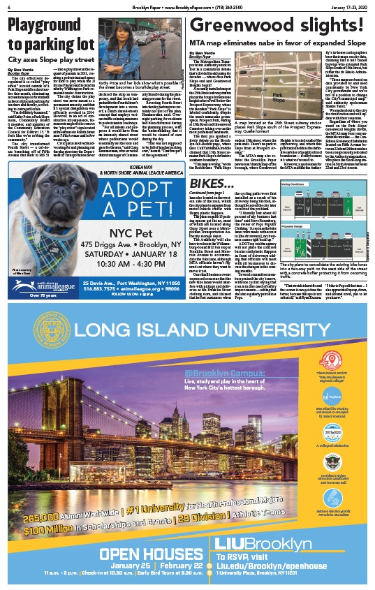
A map located at the 25th Street subway station
places Park Slope south of the Prospect Expressway.
Quelle horreur!
Photo by Ben Verde
By Ben Verde
Brooklyn Paper
The city effectively deregulated
a so-called “play
street” located outside of a
Park Slope middle school earlier
this month, eliminating
recreational space for students
in favor of placard parking for
teachers and faculty, according
to outraged locals.
“I’m definitely bummed,”
said Kathy Price, a Park Slope
mom, Community Board
6 member, and member of
the Community Education
Council for District 15. “It
feels like we’re robbing the
community.”
The city transformed
Fourth Street — a cul-desac
branching off of Fifth
Avenue that leads to MS 51
— into a play street at the request
of parents in 2011, creating
a pedestrianized space
for kids to play while the JJ
Byrne Playground located in
nearby Washington Park remained
under construction.
The city claims the play
street was never meant as a
permanent amenity, and that
it’s special designation was
officially revoked in 2014.
However, in an act of constructive
incompetence, bureaucrats
neglected to remove
the “play street” sign located
at the entrance to Fourth Street
near Fifth Avenue until a few
weeks ago.
Civic gurus involved in advocating
for and planning out
the play street say the Department
of Transportation never
Kathy Price and her kids show what’s possible if
the street becomes a bonafide play street.
City axes Slope play street
declared the strip as temporary,
and that locals had
pushed for the Fourth Street’s
development into a woonerf,
a Dutch shared-streets
concept that employs various
traffic calming measures
to pedestrianize roadways.
“For all intents and purposes
it would have been
an intensely shared street
where pedestrians would
essentially set the tone and
pace for the area,” said Craig
Hammerman, who served as
district manager of Community
Board 6 during the planning
process for the street.
Reverting Fourth Street
into faculty parking was certainly
not part of the plan,
Hammerman said. Overnight
parking for residents
had been discussed during
the planning process, with
the understanding that it
would be cleared of cars
during the day.
“That was not supposed
to be full of teacher parking
ever,” he said. “That was part
of the agreement.”
/www.BrooklynPaper.com
/www.BrooklynPaper.com
/animalleague.org